Floods and heavy rain
Floods are natural events that occur at varying levels and at irregular intervals.
Due to its location on the Alzette River, the municipality of Roeser has always been affected by flooding. This is particularly likely during the winter months after prolonged rainfall, possibly combined with snowmelt.
Climate change is exposing the inhabitants of the municipality of Roeser to increasing risks from heavy rainfall and flash floods. These are based on fundamentally different mechanisms and require adapted action plans to control them.
Flooding and heavy rainfall only cause catastrophic damage because flood-prone areas have been built up with flood-sensitive structures. Walls and dykes cannot prevent flooding. There are also strict limits to the control of flash floods due to the enormous amounts of water involved and the time available.
The dangers can only be reduced through comprehensive risk management. This involves not only considering a current flood or heavy rainfall event, but also using the time between events to prepare defence and rescue measures.
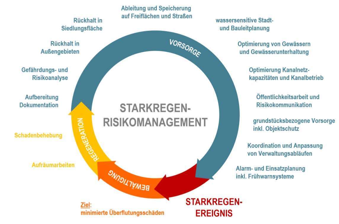
The Luxembourg Water Management Authority has proposed measures to protect against flooding in a comprehensive, nationwide flood risk management plan and the management plan based on it.
The continuation of risk management at municipal level is the responsibility of the municipality. The primary objective is to improve the self-protection measures taken by the municipality and those affected. Depending on the local conditions, appropriate preventive measures are compiled and implemented when drawing up the concept. Those affected by damage are involved in the process.
The municipal flood and heavy rain prevention plan for the municipality of Roeser (which will be made available here after completion of the project) focuses primarily on heavy rain/flash floods. Each of the seven localities of the municipality is considered separately.
The project is the result of close cooperation between the water management authority, the municipality and the engineering firms involved, and is 100% funded by the Water Management Fund.
![]()

Citizen participation
The citizens of the municipality of Roeser can contribute to the development of the municipal prevention plan in various ways, report problem areas and suggest measures:
- Information meeting on 16 October 2025 (Presentation 1; Presentation 2)
During the course of the project, on-site consultations are planned for citizens whose buildings are at risk during heavy rainfall. During the joint inspection, the entry points of water into the building will be identified and property protection measures proposed. The costs of this consultation, which will be carried out by the Remerschen-based engineering firm eepi Luxembourg S.à r.l., will be covered in full by the Luxembourg Water Management Authority. A high percentage of the resulting concrete construction measures will be subsidised.
During the joint inspection of the building and the property, citizens can also identify problem areas in public spaces (e.g. blocked street drains, surface water flowing down slopes into residential areas, etc.) and make suggestions for improving the situation. The engineering firm will review these suggestions and, if appropriate, include them in the municipality's comprehensive list of measures.
If you are interested in such a consultation, please fill out this registration form and send it to the engineering firm eepi Luxembourg Sarl.
Hazard maps
Detailed maps of the risk of heavy rain and flooding
Geoportail
On the Geoportail the official flood and heavy rain hazard maps for the entire Grand Duchy of Luxembourg can be found
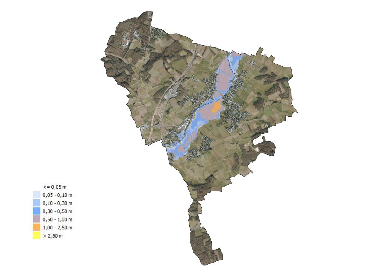
The flood hazard maps can be found under Topic: Water → Flood Risk Management Directive → Flood Hazard Maps 2021. Three flood scenarios were distinguished:
- Floods with a low probability (extreme events that occur less frequently than once every 1,000 years on average)
- Floods with a medium probability (events that occur once every 100 years on average and less frequently)
- Floods with a high probability (events that occur approximately once every 10 years on average)
The flood hazard maps show the following for these three flood scenarios:
- the extent of the flooding (area) and
- the water depth or, where applicable, the water level in the flooded areas
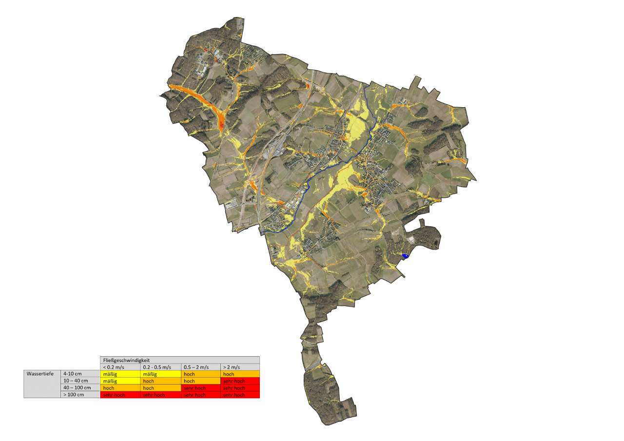
Under Topic: Water → Flood Risk Management Directive → Heavy Rain, the risk posed by heavy rain can be displayed.
Unlike for floods, only an event with a medium probability was considered here, which occurs on average once every 100 years or less.
A uniform rainfall duration of one hour was set for Luxembourg. In the Roeser municipality, this amounts to between approx. 54 and 58 mm (=l/m²), depending on exposure and altitude.
The heavy rainfall hazard atlas does not provide any information on water depths; instead, the risk is indicated in classes depending on the water depth and flow velocity.
Flood
A familiar problem
Flooding is a hazard that everyone in the country is now familiar with. This natural disaster occurs when large amounts of water overflow the banks of rivers, lakes or streams and flood the surrounding land, as was recently the case in Roeser in 2021. The effects of flooding can be devastating, but over time people have learned to prepare for this hazard. Nevertheless, the threat of flooding remains a constant challenge, especially as the intensity and frequency of flooding events is increasing due to global climate change.
Areas at risk
In the past, the Water Management Authority has mapped the extent of flooding from major flood events on the Alzette and other high-risk waterways. On this basis, it has identified ‘official flood zones’. These are designated in order to preserve natural floodplains and to provide space for floodwaters to overflow. Without these areas, the masses of water flow unchecked downstream, exacerbating the situation there.
However, it is conceivable that – albeit rarely – an even greater flood could occur, flooding areas that have not yet been affected [2].
The official flood hazard maps can be viewed on the Geoportal (see the Hazard Maps section).
Water levels and forecasts
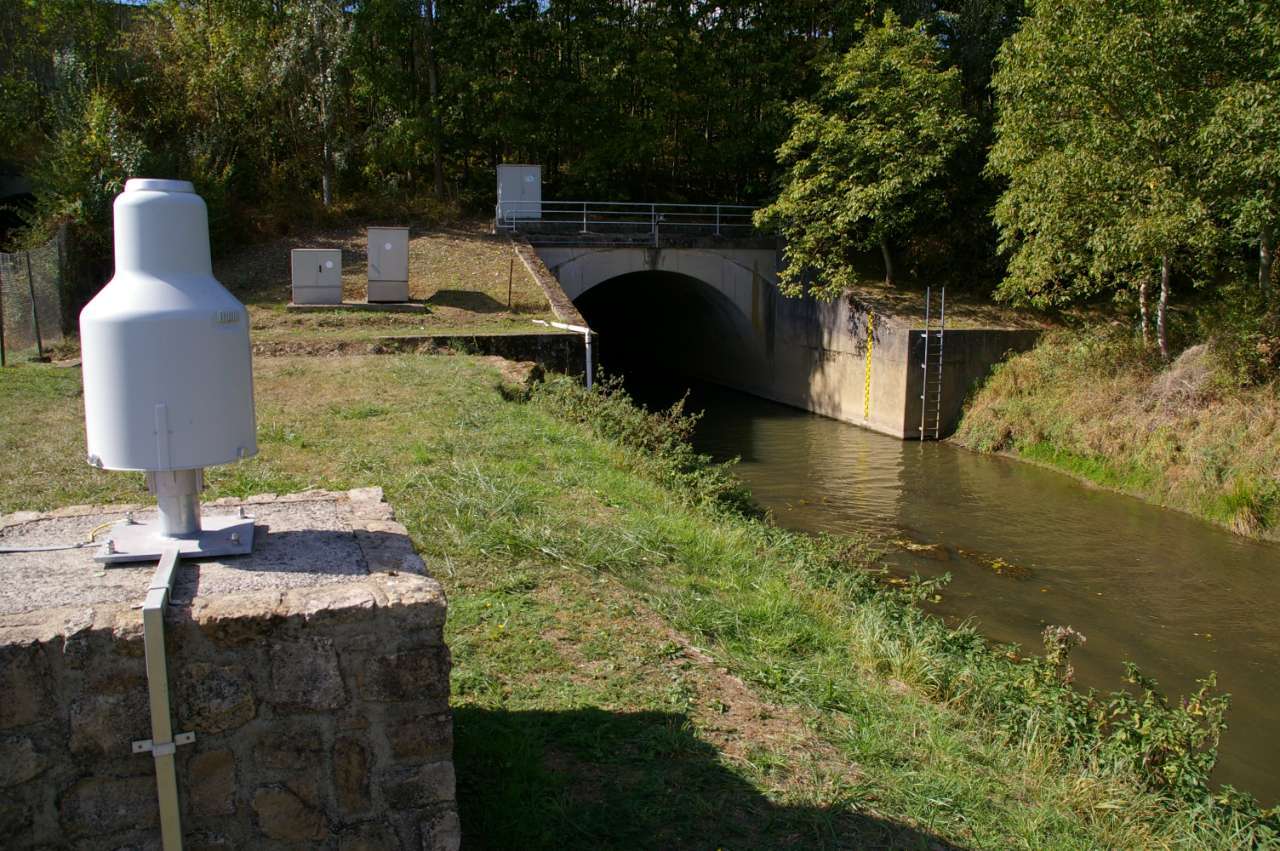
The water level in the Alzette is measured in the municipality of Roeser at the Livange gauge (river kilometre: 54.34 km above the mouth of the Alzette).
The Livange gauge is operated by the Administration de la gestion de l’eau. Water levels and forecasts can be found at www.inondations.lu.
Information channels
Internet: Status reports, forecasts, hourly updated water levels, maximum levels and hourly updated water level overviews can be found at www.inondations.lu. Further information can be found at infocrise.public.lu.
Meteorological data and forecasts can be found on the Meteolux website.
Apps: Various apps can also be used to find out about the current water level and receive warnings:
The emergency information app „LUAlert“ is part of a comprehensive programme to raise public awareness of risks and promote self-protection measures. In addition to flood warnings, it also provides information about existing warnings of heavy rain, storms or major fires.
The DWD's „Meteolux“ app also provides current warning and weather information and makes forecasts for weather developments in the coming hour.
Radio: Water level announcements and situation reports on the radio programmes of all local stations (only during floods).
Heavy rain
Heavy rain nearby
Climate change is leading to changes in precipitation patterns, with heavy rain becoming increasingly frequent.
"Urban flash flooding refers to the flooding of a residential area resulting from heavy rain, which often occurs locally. Such precipitation occurs mainly during the summer months and brings very large amounts of rain to areas of a few square kilometres in a very short time. It is often accompanied by thunderstorms and hail." [5].
"Unlike river flooding, there is currently no significant warning time for flash floods. The heavy rainfall runoff from flash floods often far exceeds the capacity of property drainage systems, sewers and waterways. Rainwater and sludge then flow uncontrollably from agricultural, forestry and other outdoor areas via ditches and paths into residential areas. Small drainage ditches, streams and roads become raging torrents and the surface water flows uncontrollably to the lowest points of the terrain. Properties and buildings are flooded; rescue access routes are cut off. Buildings, technical installations, intangible assets and property are destroyed within a very short time." [5].
Reports of catastrophic heavy rainfall events and flash floods are becoming increasingly frequent. The extent of damage caused by flash floods in Greece, Spain and Syria in autumn 2023 far exceeds the catastrophic flooding on the Ahr, in the Eifel and along the Sauer on 14/15 July 2021. The amount of rain that fell within a very short period of time led to large-scale soil erosion, which poured into the local areas as mud.
The heavy rainfall index was developed to classify heavy rainfall, also with regard to the contribution of the sewer network to the drainage of rainwater. It has 12 levels. The standard drainage of residential areas is usually designed for a maximum 5-year event, corresponding to heavy rainfall index 2.

Areas at risk
The official heavy rain hazard maps, which can be viewed on the Geoportal (see Hazard Maps section), are based on a 2-metre model grid, which means that it is not possible to derive reliable water depths. The heavy rain hazard atlas shows flow paths and qualitative flow depths very well on a large scale. Locally, however, the use of 2-metre tiles can lead to a specific point, e.g. the location of a critical infrastructure facility, being unrealistically flooded or to incorrect water depths being displayed.
As part of the heavy rainfall and flood prevention concept of the municipality of Roeser, detailed models based on a finer grid (0.5 x 0.5 m resolution) were therefore created for selected high-risk districts with known heavy rainfall problems. These detailed models, which also include culverts and passages and take the sewer network into account, were used to create new heavy rainfall hazard maps for the municipality. These maps can be found in the section Hazard maps.
Precaution
To protect against adverse consequences and to mitigate damage, all persons potentially affected by flooding and/or heavy rainfall are advised to take effective precautions. Information on funding opportunities can be found in the Water Management Administration brochure Erläuterung zur staatlichen Förderung von Objektschutz an Gebäuden gegen Hochwasser.
Unlike in neighbouring Germany, there is no obligation to take precautions oneself, either in Luxembourg's water law or in the Civil Code. Depending on the intensity of the event and the extent of the flooding, affected citizens cannot rely on the municipality to come to their aid.
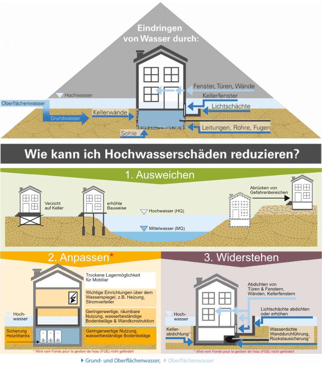
How can water get into my house?
Water – whether from flooding or heavy rain – can get into a house in lots of ways. You can protect yourself against water getting in by building and using your house in a way that's flood-proof. The simplest thing to do is to put sandbags in front of doors and windows.
You can find specific info on protecting your building and structural precautions, for example:

- in the Ratgeber Land unter [2]
As part of the prevention plan to protect the municipality of Roeser from flooding and heavy rainfall, free on-site consultations are available for individual buildings. More information can be found in the Citizen Participation section.
Insurance cover
The best way to prevent damage from flooding is to take precautions. Install suitable protection systems and move valuable furniture or objects and installations such as heating systems in good time to areas that are not at risk of flooding. However, damage cannot be completely ruled out.
Natural hazard insurance can cover material damage caused by heavy rain, high water and flooding. In particularly vulnerable areas, this is often very expensive.
The specifications and requirements of the insurers must be strictly observed. If, for example, the drainage of the property does not comply with the rules of technology, for example if there is no backflow protection, insurance companies may limit or even refuse their benefits.
To reduce the risk, you should clarify with your insurer to what extent natural hazards are covered by the insurance.
Behaviour in an emergency
Remain calm and level-headed, and follow the instructions of the emergency and rescue services on site.
When, where and how can I find out about the flood?
With the help of flood hazard maps, affected citizens can find out at any time whether they live in an area at risk. If this is the case, you should regularly check the current water level and the forecast.
Information on water levels and forecasts can be found here on our website under the section Flood, under Water Levels and Forecasts. On the Meteorological Hazards page you will find information on the effects of flooding and recommendations for dealing with it.
What basic personal equipment do I need?
Many aids that are useful in an emergency can be easily obtained in advance. The following items are very important for your basic personal equipment, which will make you self-sufficient for several days in the event of flooding.
You can find a detailed checklist for your basic personal equipment in the brochure Ratgeber Land unter.
Take notes
If you are affected by flooding for the first time, take notes. Write down the current water levels and create a table with water levels and reference points that are critical for you!
What is the situation at certain water levels in your immediate neighbourhood? At what water level does the water reach your house?
This way, you will be better prepared for the next flood or heavy rainfall and can take preventive measures in good time.
What else needs to be done?
Remove your vehicles from the endangered areas in good time and find out where you can park them. When driving away, do not obstruct the emergency services or your neighbours.
Make sure in good time that sick and care-dependent persons are accommodated with relatives and friends. If this is not possible, organise help through private services or aid organisations. This will ensure that medical care and support can be maintained. Remember that aid organisations cannot come for minor issues. In the event of an acute health risk, dial the emergency numbers 112 or 113.
Bring your animals to safety in good time.
Cellars, garages and lower-lying rooms are often the first to be affected by flooding. If water is at the door, staying in basements can even be life-threatening..
Then remove containers of waste oil, chemicals, paints, varnishes, detergents and cleaning agents from low-lying rooms. Oil and other water-polluting substances in flooded areas not only contaminate the water and your rooms. The flooding also causes damage to the surrounding area.
If, despite all precautions, environmentally hazardous substances leak, notify the fire brigade immediately. Any delay will exacerbate the damage many times over.
Move your furniture to higher floors at an early stage. Ask your family, friends or neighbours for help and support each other. If necessary, organise professional help from removal companies.
Turn off the main gas, water, electricity, heating and oil valves.
Make sure you have emergency lighting. Your electricity supplier can tell you if and when the power will be cut off in your neighbourhood.
Heating systems (burners and boilers) should be switched off in good time. This allows the appliances to cool down sufficiently before they are dismantled. You should also make an appointment with a specialist company in good time. Local heating engineers have a lot to do when flooding is imminent. If you have gas heating, don't forget to close the gas valves.
Oil tanks and their connecting pipes must be firmly anchored to the ground. Otherwise, the tank may become detached due to buoyancy in the water. Water exerts pressure on the tank from the outside. This problem can be avoided by filling the tank completely before flooding occurs. The oil then forms a counterpressure to the water.
Keep a mobile phone with a charged battery ready. Neighbours should help each other if the landline network fails.
Be sure to secure household waste bins to prevent them from floating away.
Prepare waterproofing measures (sandbags, dam beams, etc.).
Pumping out water:
The fire brigade does not usually provide pumps during the flood phase. Pumping water out of low-lying rooms during a flood is also not without risk. The rooms that have been pumped empty can collapse under the immense water pressure from outside. Under certain circumstances, the stability of your building may be compromised.
If necessary, take time off work. The fire brigade can only help in exceptional cases.
Help your neighbours too!
What should I do after the flood?
Please remove the mud from your building as quickly as possible before it dries out and becomes more difficult to remove.
Once the mud has been removed from the affected buildings, you should start drying the building as quickly as possible. For safety reasons, you should first check whether there is a risk of electric shock and whether any chemicals or heating oil may have leaked. Food that has come into contact with the water should be disposed of.
Please document all damage with photographs and inform your insurance company.
Contact persons
Technical service of the municipality |
eepi Luxembourg Sarl |

Emergency number CGDIS 112:
In case of danger to life and limb, severe damage to the building, leakage of hazardous substances or severe damage to the building
Sources
[1] Handlungsempfehlungen zur Erstellung von Starkregenkarten im Saarland, „Hochschule Kaiserslautern, Fachbereich Bauen und Gestalten, Professur Siedlungswasserwirtschaft,“ Kaiserslautern, 2019.
[2] Ministerium für Umwelt, Forsten und Verbraucherschutz Rheinland-Pfalz, „Land unter - Ein Ratgeber für Hochwassergefährdete und solche, die es nicht werden wollen,“ Mainz, 2008.
[4] Bayerisches Landesamt für Umwelt (LfU), „Hochwasser-Eigenvorsorge: Fit für den Ernstfall,“ Augsburg, Aktualisierung 2018.
[5] Bund der Ingenieure für Wasserwirtschaft,Abfallwirtschaft und Kulturbau (BWK) e.V., Starkregen und urbane Sturzfluten - Praxisleitfaden zur Überflutungsvorsorge, Juli 2013.
[6] Administration de la gestion de l’eau, „Leitfaden für Bauvorhaben innerhalb von Überschwemmungsgebieten“, 2018
navigation sur le site
Contact & Opening Hours